GMNS
duckosm gmns monaco.duckdb             # -> monaco_gmns.duckdb
duckosm gmns monaco.duckdb --to-csv gmns/     # also the spec CSVs
GMNS (General Modeling Network Specification) is the
open table format of DTALite, Path4GMNS and other network-modelling tools. duckOSM writes every
GMNS table that OSM has data for into one new DuckDB file that stands alone: it doesn't need
the source database, and its tables carry real geometry, so you can query and draw them.
--to-csv DIR also writes the standard node.csv, link.csv, lane.csv, … into DIR/<mode>/.
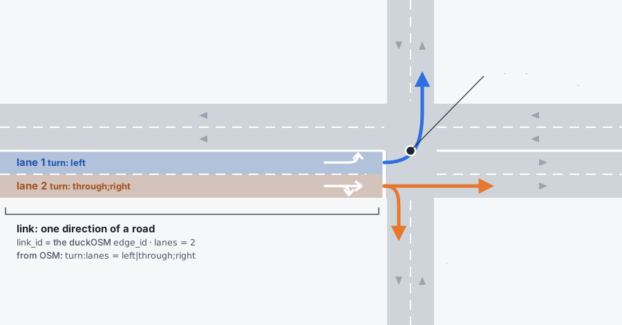
The CSVs have only the columns the spec defines, so the geometries and each lane's turns stay in the
DuckDB file.
What's in it
Every table, column by column, with where each value comes from: GMNS tables.
One schema per mode, gmns_driving, gmns_walking, gmns_cycling. Monaco, driving:
| Table | Rows | What |
|---|---|---|
node |
1,719 | junctions; ctrl_type = 'signal' at traffic lights |
link |
2,765 | directed roads (in driving also the 18 bus-only directions, one bus lane each: link): link_id = edge_id, length, speed, lanes, capacity (a per-lane default by road class), facility_type (the OSM highway), name, and (DuckDB only) bridge / tunnel / layer |
lane |
3,182 | one row per lane, with its turns, allowed uses and width where OSM tags them |
movement |
3,500 | legal turns (from edge_graph; turning back along the same road only at a dead end, or where it's the only way into the road's other direction): type (left, thru, right, uturn, merge, diverge), code (NBL, EBT, …), the lanes it starts from and ends in (equal-length ranges read in order: from turn:lanes where tagged, else osm2gmns's rule, design), a curved turn path |
crossing, lane_crossing |
duckOSM extension | the pedestrian crossings painted on the driving lanes, and which stretch of each lane they cover (in gmns_driving only): from the OSM crossing ways and the crossing nodes that have no way (design) |
link_along |
duckOSM extension | one road a footpath runs along (a footpath often runs along several): its link_id, the road's along_link_id and network, the metres along it and the gap; the roads are ones cars can use, of the footpath's own level. The link also has along_link_id / along_mode / along_gap_m / along_kind for the road with the longest stretch (columns) |
lane_connector |
duckOSM extension | one path per lane pair of a movement: a curve from the end of one lane to the start of the next (from_lane_id, to_lane_id, mvmt_id, width, geom); lanes stop where a junction starts or where they'd jump sideways, and the connector joins them; a U-turn at a road end is a half-circle as wide as its lanes; with driving and walking exported, gmns_walking.lane_connector also holds a footway's join to a road lane at a shared node (design) A road's pieces are placed as one run, so a lane going on through a junction or a bend is one continuous line (design). |
geometry |
2,765 | link shapes |
signal_controller |
1 | where the traffic lights are (OSM has no timings) |
curb_seg |
2 | on-street parking, where OSM tags parking:* |
location |
1,803 | OSM points on a link: crossings, give-way and stop signs, signals, parking entrances |
zone |
1 | the area: every node is in it; its outline when the database was built with a boundary |
config, use_definition, use_group |
units (metres, km/h), CRS (EPSG:4326), modes |
Tables GMNS defines but OSM has no data for (signal timing, time-of-day) are left out, as the spec intends: see GMNS tables.
Lanes from OSM tags
Every link gets its lanes from its lane count; where OSM has the details, they're filled in:
| OSM tag | Gives |
|---|---|
lanes, lanes:forward, lanes:backward |
the number of lanes each way |
turn:lanes |
each lane's turns, and which lanes feed each movement |
width:lanes |
lane width (empty where untagged) |
bicycle:lanes, psv:lanes |
bike and bus lanes |
Most ways have none of these (Monaco: turn:lanes on 0.4 % of roads), so most lanes are general
lanes with no width. Lane details need the raw OSM tags, which a PBF build keeps; an area clipped
from a bigger build (source.type: duckdb, duckosm extract) gets lane counts only. Each lane also
has a centre line drawn beside the road, on the traffic side, 3.25 m apart (--drive-side left for
left-hand traffic). A road mapped as two one-way ways, one per direction, drawn closer together
than its lanes need, is placed as one road: each direction's lanes start from the line midway
between the two ways, so the directions never overlap (--no-pair-carriageways turns this off;
design).
In the walking network a footpath (footway, path, steps, …) is one 2 m strip for both of its directions, centred on
its line (people walk both ways on it). A sidewalk (footway=sidewalk) is placed from the cross-section of the road it runs
along, not from its own OSM line: its lane lies just outside the road's kerb-side lane (the road's lanes from
gmns_driving where it is there), so it never lies on the carriageway (--no-walk-frame turns this off,
--walk-clearance M leaves a gap to the kerb; only a mapped sidewalk moves, no footpath is put where OSM has none; a sidewalk that still lies on a road (its road on its far side, too far, or none found) is pushed out across the road to the nearer kerb, half its width beyond it, so a street does not lose a side;
design).
Meso and micro networks
For simulators that work below the road level:
duckosm gmns monaco.duckdb --meso --micro
- Meso (
meso_driving): each road becomes a section, and each legal turn a connector between sections. Monaco: 2,765 sections + 3,500 connectors. - Micro (
micro_driving): each lane cut into 7 m cells, with lane-change links between side-by-side cells and turn links across junctions. Monaco: 25,423 links.
Both are modelled on osm2gmns' (not identical: see GMNS tables); their ids are built from edge_id (M<edge_id> for a section,
X<from edge_id>-<to edge_id> for a meso connector), so they stay the same across rebuilds and lead back to the road.
Driving by default; --meso-mode cycling / --micro-mode cycling for cycling.
All modes in one network
--combined adds gmns_all: one link table for every mode, a road shared by several modes
being one link with allowed_uses = 'auto,bike,walk'. Monaco: 12,789 links.
See it
duckosm gmns-viz monaco_gmns.duckdb                 # inspect: lanes (+ meso / micro if built), hover for ids
duckosm gmns-map monaco_gmns.duckdb                 # present: every lane at its width, on a base map
Each writes one HTML file. -m picks the mode. gmns-map draws with
lanestyle (pip install "duckosm[viz]").
Monaco's lanes, as gmns-map draws them (scroll to zoom, drag to move): each lane is a strip of
road with its lane lines and an arrow for its direction, and bridges and tunnels keep their order.
Click a lane: it turns red, and the lanes its movements lead into turn green. Bus and bike lanes
get their own colour.
Options
| Option | Does | Default |
|---|---|---|
-m, --mode |
modes to export; repeat for several | every mode in the db |
-o, --out |
output file | <name>_gmns.duckdb |
--to-csv DIR |
also write the spec CSVs | |
--meso, --micro |
also build the meso / micro networks | off |
--meso-mode, --micro-mode |
their modes | driving |
--combined |
also write gmns_all |
off |
--drive-side |
right or left traffic |
right |
--no-pair-carriageways |
centre each one-way way's lanes on it, even beside its opposite direction | paired |
--walk-frame |
move a mapped sidewalk off the carriageway (placed from its road's kerb, or pushed to the nearer kerb) and join the footways that meet it | off: footways stay as OSM maps them |
--walk-clearance |
gap in metres between the kerb and a footpath placed from its road | 0 |
--no-lane-geometry |
skip the lane centre lines | computed |
--gtfs FEED |
a GTFS feed (.zip or folder, repeatable): its stops become location rows with their gtfs_stop_id (how) |
none |
--gtfs-max-m |
how far from a link a GTFS stop may be and still be put on it | 30 |
--csv-extensions |
keep duckOSM's extra columns in the CSVs, as u_-prefixed user-defined fields |
standard columns only |
--check |
check the values of the result (see Conformance) and exit 1 if one fails; also prints how connected each network is (information only) | off |
from duckosm import to_gmns, to_meso, to_micro
to_gmns("monaco.duckdb", "monaco_gmns.duckdb")
to_meso("monaco_gmns.duckdb")          # on an existing GMNS db
to_micro("monaco_gmns.duckdb", cell_length_m=7.0)
Conformance to the GMNS standard
The CSV output (--to-csv) is checked against the spec's own schemas, release v0.97, with
frictionless: tests/test_gmns_spec.py runs it on every test
build, using the schemas in tests/data/gmns_spec/. It also checks the values the spec lists as
categories (ped_facility, bike_facility, movement type, ctrl_type). Run it on your own output:
duckosm gmns area.duckdb --to-csv gmns/
# put the spec's datapackage.json and *.schema.json (release v0.97) next to the CSVs, then
frictionless validate datapackage.json
The spec's validators check the shape of the tables, not what the values say about each other.
duckosm gmns ... --check does (duckosm.check_gmns(path) from Python): a link starts and ends on its
nodes; link.length is its geometry's length; lane_num runs 1..n and link.lanes is the number of
lane rows; a movement turns at the node where its inbound link ends, and its lane ranges exist and are
as long on both sides. Run on Monaco, Södermalm, Tartu and Granville Island, in every mode: all pass.
What differs from the spec, on purpose: the DuckDB file has extra columns (geom on node, link,
geometry, lane, location and zone; lane.turn; link.osm_id, bridge, tunnel, layer; location.osm_id; signal_controller.node_id,
control_type) and a lane_connector table; the CSV leaves them out. A U-turn has no mvmt_code
(the spec's code has no U; type is uturn). OSM sidewalk and cycleway are mapped to the spec's
categories, so which side a sidewalk is on is lost. The optional spec tables segment*, *_tod and
the signal timing tables are not written. Walking and cycling links that cars cannot use have no lanes or
capacity (the standard defines both for motor vehicles). Design and audit:
gmns_spec_conformance.
duckOSM and osm2gmns
osm2gmns is the established OSM-to-GMNS tool. Run on the same Södermalm PBF:
| duckOSM | osm2gmns 0.7 | |
|---|---|---|
| Ids | edge_id, the same on every rebuild |
numbered from 0 on each run |
| Lanes | per-lane turns, bus and bike lanes, widths from OSM tags | lane geometry |
| Turns | from the graph of legal turns (OSM turn restrictions kept) | from geometry |
| Complex junctions | kept as in OSM | merged into one |
| Modes | all in one file, sharing ids | one network type per run |
osm2gmns goes further for simulation (junction consolidation, a mature micro network); duckOSM's network keeps stable ids and more of OSM's lane data. They work well together.